This is the Sharphill Action Group’s response to the following application made to Rushcliffe Borough Council
Ref 20/03213/REM: Various Reserved Matters for 137 homes on part of area off Melton Rd, Edwalton covered by Applic No. 17/00941/OUT (OS Field 7525)
Comments by Sharphill Action Group 30th Jan 2021
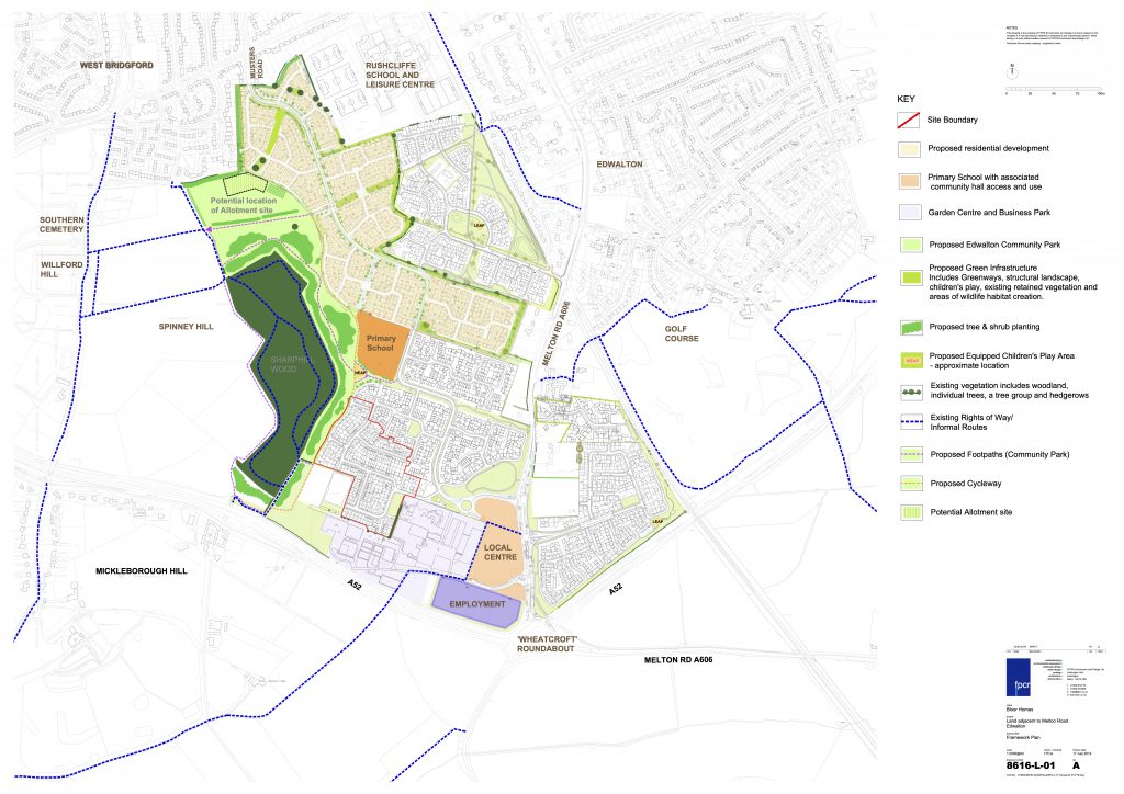
The Sharphill Action Group (SAG) wishes to make several representations in response to the above application that lies in Zone 4 (Phase 4) of an emerging development off Melton Road which is situated in an area that is subject to an outline approval for about 600 homes. It is noted that the previous application (20/00596/REM) on the same site was refused in Sept 2020 by the Borough Council on the grounds of its poor contribution to the public realm /sense of place and lack of accord with the Development Framework Supplementary Planning Document (approved in 2015). There were also issues of substandard outdoor amenity space, unbalanced affordable housing mix and an unacceptable access/highway layout.
1) The proposed layout shows no additional provision of play and sports areas for older children as required by the Local Plan Part 1(Policy 20 E16) and the Development Framework (DF). One junior play area alongside the proposed primary school to the south of the site appears insufficient for the size of population to be served, given the absence of any community access agreement to use the proposed all-weather pitch at Rushcliffe School and the distance from Gresham fields. The land of Zone 4 in the NW corner of this site represents one of the last opportunities to make good on this deficit. For instance, a small, enclosed play pitch could be located in place of the awkwardly positioned single Plot 108 which abuts Zone 2.
2) Although a certain amount of re-contouring of the steeper parts of the site is proposed, SAG is concerned that significant building on the slopes of Sharphill Wood may impair views of it, contrary to the intentions of the DF.
The DF aims to “create open and channelled views towards the Community Park and Sharphill Wood” in accordance with its design code(p.36). Distant views have been recognised as important from across Nottingham in addition to any local ‘channels’. Thus SAG maintains it is incumbent upon the Borough Council to restrict over-intensive layouts where the land steepens closer to the Wood as well as to protect the ridge-line from building incursion in order to benefit the wider public realm. In this context, the landmark 2.5 storey block of flats (Plots 60-68) in the north-west corner of the site is probably inappropriate and should be re-located. Its prominent setting is highlighted in Figure 17 (Street Scene B) of the Design & Access statement (DAS) where several 3-storey town houses should also be reduced to 1-storey height. There is perhaps a clear case for judicious use of ‘green’ roofs in this and other areas.
The proposed layout raises the question of how vehicular access to the community parkland or ‘greenway’ to the west of the site might be achieved or restrained. Here it would seem that the turning head and access lane to Plots 20-24 and 30-31 (which lie adjacent to the main N-S footpath/cycleway) and the shared drive serving Plots 58-68 may attract ‘unwanted’ parking.
3) Whilst the 30% level of affordable housing is welcomed as generally standard throughout this 45 ha. urban extension at Edwalton, and the range of housing types has been expanded since the previous application, there appears to be insufficient detail on the different tenures of these homes. Consequently SAG believes that the Borough Council should press for more in the social rented category where the need will continue to be strong.
4) SAG is concerned at the continuing absence of a stand-alone Community Hall in plans for this Zone given that other site opportunities have been spurned or found to be unfeasible. Such a facility was always intended in the residential heart of the development alongside “a neighbourhood centre of appropriate scale” as per the provision in Policy 20 C6 and the location shown in Figure 1 of the approved Local Plan Pt.1 (Core Strategy). In the subsequent DF this became a Local Centre incorporating “retail and other local community facilities and uses” on the west side of Melton Road, but the Borough Council has so far evaded its responsibility to ensure that one is delivered.
It was clear from the outset that the school hall (and adjacent rooms) within the Primary School could not be used for the range of community functions that would be needed. In the five years since the DF was approved, it is unfathomable why an alternative central site has not been found, especially as there should be sufficient monies available from the ‘roof charge’ contributions to the pooled infrastructure funds due to the large number of ‘surplus’ homes (estim +18%) so far approved beyond the 1500 allocation (see item 7 below).
5) The layout plans do not indicate where bus stop locations will be established on this section of the spine road as per the Bus Infrastructure Delivery Plan, and the DAS does not confirm any incentives for early provision of the bus route, and for its subsidised use by first residents, as recommended by the County Council’s Transport & Travel Services team.
6) SAG has commented at the outline planning stage that sustainability is poorly realised in the proposed energy provision of the DAS serving Zone 4 of this development. For a sustainable urban extension (SUE) in a time of climate crisis, a commitment to design zero carbon rated and climate robust buildings, and to install some renewable-ready equipment (especially where a largely south facing site lends itself to solar generation) in/upon them, should be regarded as essential. The Sustainability section of the DAS is remarkably non-committal on this subject, retreating into vague language such as energy efficiency ”will be encouraged” and “it is anticipated that all dwellings will include a range of water saving measures”. The Borough Council should be far more active in insisting on the highest standards if it is to meet its objectives in Policy 2 (Climate Change) of Local Plan Part 1, especially where, as in this case, the development is situated on very exposed, elevated land.
7) SAG notes the surplus of houses overall across the SUE, which exceeds the allocation of 1500 by an additional 18% at least, with approx.1770 already approved or completed. This may serve to invalidate the conclusions of a number of studies carried out to establish the extent of the required common infrastructure, both on and off-site (esp. for drainage). Such a surplus now gives the local planning authority scope to reduce the number of buildings that impede views of the ridgeline and of hard surfaces that create excessive water run-off by a more vigorous interpretation of key outline planning conditions and of the design principles and green infrastructure strategy of the DF.
Finally, there is a drafting error evident from the key of the Framework Plan (Figures 02 & 12) in the DAS where the notion of a potential access for local traffic from Musters Road is perpetuated, causing some confusion. This appears to be a hangover from the 2017 outline application, since when the secondary access has been reserved for buses and emergency vehicles only.
SAG recommends that the above matters are fully reviewed to ensure that plans and agreements are amended accordingly. It thus wishes to lodge objections to this application -which we trust will be considered by the Planning Committee in due course (please advise when).